After the dramatic death toll in the Philippines, it’s the time to evaluate also the damage caused to agriculture by Typhoon Haiyan , the most dangerous tropical cyclone to affect the country. Particularly at risk is the cultivation of rice, the most important food of all the countries of south -east Asia. Some satellite images released in an article published by the International Rice Research Institute (IRRI ), the most important institution of research in the field, which is based in Los Baños, showing flooded rice farms and buildings that were damaged by Typhoon Haiyan (local name Yolanda) in the northeastern part of Leyte Province[1].
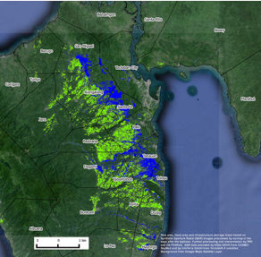
Photo 1: one of the maps released by IRRI with the aim of assisting the Philippine government in its work of recovery of the areas subject to typhoon Haiyan . (Click here to see other maps )
The satellite-generated maps, developed by the International Rice Research Institute (IRRI ) in collaboration with Sarmap and the Department of Agriculture- Philippine Rice Research Institute (DA-PhilRice), show that flooding has affected about 1,800 hectares of standing rice crop across 15 municipalities and that the typhoon badly damaged buildings where harvested rice may have been stored. The time might play an important role in the efforts that the government is doing to rebuild the country after the hurricane. The availability of this information in a short time would could allow, for example, the Philippine Department of Agriculture to better assess the effects of this calamity on the rice growing areas affected by the typhoon and therefore better plan their rehabilitation intervention. It’s convinced of this the Secretary of the Department, Dante Delima, coordinator of the National Rice Program, which also claims to have high expectations towards the opportunities offered by research on Remote Sensing for better monitoring and evaluation of the national rice production.
And in fact the images are quite clear: one map that showed rice fields that were flooded also showed which fields were harvested before the typhoon struck. A second map revealed extensive damage to buildings and other infrastructure, suggesting that harvested rice that was in storage was also likely damaged from wind, rain, and storm surges. Additional data released last week by the Philippine Department of Agriculture and IRRI showed that harvesting in the region is usually done from September to October and, this year, was done just before the typhoon hit on 8 November 2013. Extensive damage to infrastructure, however, will have affected rice in storage, irrigation facilities, farm equipment and, likely, planning and preparation for the next rice-growing season. The maps are based on synthetic aperture radar (SAR) images processed by SARMAP in the days after the typhoon and are the result of an international collaboration, in which Italy played an important role. The data were provided in fact by the Italian ASI/e-GEOS from COSMO-SkyMed and by InfoTerra GmbH from the German TerraSAR-X satellites.
The Earth Observation technologies for agriculture
The example of the Philippines clearly shows how the
Earth observation satellite data can be a valuable tool for the monitoring of
crops and agricultural practices on a regional scale . "The continuous release
of images captured by optical sensors and radar, says Mirco Boschetti of the Institute
for Remote Sensing of Environment (IREA)[2]
of
CNR in Milan, allows to locate the different crops on a map, to monitor its
development during the growing season, to assess its status in an early phase
of production, identifying any critical situations, and to determine any
potential losses. This information could be very useful also for policy makers
and stakeholders and for all those who have responsibility for the management
and protection of an area"
Fundamental for the application of remote sensing in agriculture is the
availability of satellite data acquired in the most suitable and appropriate
way. "In tropical areas, such as in Asia, and in case of extreme weather
events, continues Boschetti, SAR data represent the best solution due to their
ability to provide information on the territories observed even in the presence
of a dense cloud cover. Another important element, however, is the close
cooperation between the various space agencies and data providers. “In the case
of Typhoon Haynn this collaboration allowed researchers of IRRI and of
SARMAP to dispose of SAR
images immediately after the event."
Agriculture is one of the most studied areas of application of IREA,
who has been conducting research on agricultural systems, especially in
developing countries, to estimate production and to identify potentially
critical situations in support of policy interventions . The monitoring of the
production of rice in south- east Asia is also one of the issues of
collaboration with IRRI and SARMAP. But at IREA remote sensing is also used for
studying extensive pasture systems in Sub- Saharan Africa where productions are
heavily dependent on climate variability and the interaction between man and
environment[3].
Agriculture is a global issue[4] with
a great attention also at the European level, where many projects based on
aerospace technologies are supported. The rice is e.g. the subject of the
European project Ermes (An Earth Observation Model based RICE information Service)
funded under the EU FP7- SPACE 2014-2016 , coordinated by the IREA, which aims at the creation of
services for the monitoring of the rice-growing productions. In collaboration
with other European partners, Ermes intends to build a prototype of downstream
service dedicated to the rice-growing agricultural production based on an
integrated use of data from Earth observation, field observations and agronomic
modeling. Long-term goal of Ermes is to extend and adapt the service to the
context of Asian and African countries and to contribute with innovative
solutions to the objectives of sustainable development.
But agriculture is an issue that strongly affects also Italy, and in particular the Lombardy, the biggest agricultural Italian region, producing 42% of milk, 42% of rice and 39% of pork based food products. Here the requirements are varied, and range from the need to develop a shared system of knowledge at the regional level able to effectively monitor the Lombard agricultural systems, to the need to deal with water stress of crops, considering the impacts due to climate change affecting more and more frequently the territory. In this framework, the IREA also coordinates a Regional project, Space4Agri - Aerospace Earth Observation for the Agriculture in Lombardy - funded within the Framework Agreement Lombardy Region - National Research Council, whose purpose is contribute to the development of appropriate tools in innovative ways, combining remote observations from satellite, airborne technologies for UAVs and web 2.0 and Internet technologies for smart interchange of data and information.
[1] Leyte is a study site located inside the International Project RIICE (Remote Sensing-based Information and Insurance for Crops in Emerging Economies) in which IRRI, SARMAP, the Philippine Department of Agriculture collaborate with other foreign partners, such as the German Agency for International Cooperation GIZ, the company Allianz, and the Swiss Agency for development and Cooperation SDC in order to develop monitoring technologies for rice-growing areas of food security and crop.
[2] The IREA has been working for years on geomatics, remote sensing, geographic information system, focussing on methodologies and technologies for acquiring, processing, fusion and interpretation of images and data from electromagnetic sensors operating,satellite and in situ data; IREA is also involved in Spatial Data Infrastructure and in the Volounteer Geographic Information (VGI).
[3] Other fields of application of IREA researches are climatic changes, desertification process, forest fires, glaciers melting, water quality monitoring.
[4] The IREA was involved for years in several international research projects such as GEOLAND (GMES project on land cover and vegetation, EU FP6) and GEOLAND 2 (Towards an operational GMES Land Monitoring Core Service, EU FP7) under which the group research has contributed to the Core Information Service Narma (Natural Resource Monitoring in Africa) aimed at the creation of a technological infrastructure based on space technology in support of decision-makers to deal with situations of environmental and food insecutity.